From Andean peaks and Amazonian rainforests to Patagonian glaciers, Incan ruins, white-sand beaches, and pulse-pounding nightlife — South America is a continent of breathtaking contrasts and unforgettable adventures.
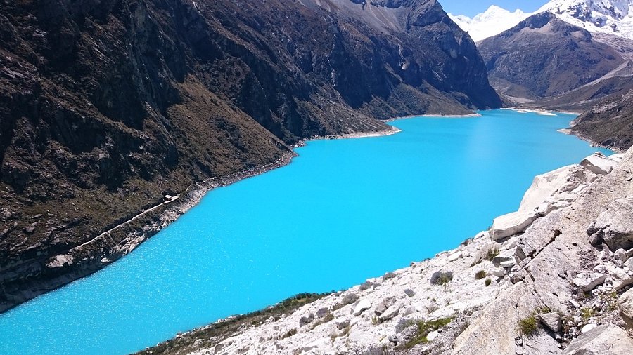
Tucked high in the Cordillera Blanca — a snowcapped range of the Andes in west-central Peru — Laguna Parón is the largest lake in the region and a captivating natural reservoir that draws hikers, climbers, and nature lovers alike.
Located in Huascarán National Park, about 100km (62 miles) north of Huaraz, the lake spans 17.1 square kilometers and sits at a breathtaking altitude of 4185 meters. Its vivid turquoise hue, caused by a high concentration of dissolved lime, is unforgettable. From its serene shores, visitors can enjoy spectacular views of iconic Andean peaks dusted with snow — including the photogenic Artesonraju, the pyramid-shaped mountain believed to have inspired the Paramount Pictures logo.
Recognized as a UNESCO World Heritage Site since 1985, Laguna Parón is accessible by car or on foot, offering an unforgettable setting for meditation, kayaking, camping, and rock climbing.
From Lima to Huaraz
To begin your journey, take an overnight bus from Lima to Huaraz (8 hours). Several companies operate this route, but MovilBus is among the most reliable.
From Huaraz to Laguna Parón (via tour)
Once in Huaraz, you’ll find many agencies offering full-day tours to Laguna Parón. Expect to pay between S/50–70 per person for a group tour with a certified guide. These tours typically depart around 7:30–8:00am. Use your arrival day to acclimatize — Huaraz itself sits at over 3000 meters.
From Huaraz to Laguna Parón (DIY)
If you’re traveling independently, take a public “combi” (shared van) from Huaraz to Caraz (about 2 hours, S/6–8). Vans depart regularly from Jr. Cajamarca, a 10-minute walk from the main plaza.
From Caraz, hire a taxi to Laguna Parón. Round-trip fares typically range from S/150–180, including a 2–3 hour wait. The journey takes about 90 minutes on bumpy mountain roads.
Adventurous travelers can hike to the lake from the small town of Parón (S/8–10 from Caraz). The steep, rocky trail stretches 8 miles and takes 3 to 5 hours, depending on your pace and acclimatization.
Be aware: trail signage is minimal, so consider hiring a local guide or downloading Maps.me or a similar offline GPS app. If you plan to return the same day, make sure to be back in town by 3pm to catch the last combi, or arrange for a return taxi in advance.
Kayaking & Boating
Paddle across the icy, glassy waters in a kayak for 30 minutes (S/20), or opt for a brief 15-minute boat ride (S/10 per person).
Rock Climbing
Advanced climbers can scale Torre de Parón, also known as the Sphinx, a granite monolith with over a dozen established climbing routes.
Hiking to the Mirador
Take the 30–40 minute marked trail to the Mirador, a viewpoint that offers a breathtaking panoramic of the turquoise lake and surrounding peaks — ideal for photos and a quiet moment above the crowds.
Camping
For the full experience, pitch a tent by the lakeshore. Camping is free, but there are no facilities, so bring your own gear, warm clothing, food, and water — and pack out all waste to help protect the pristine environment.
Park Entrance Fee: S/5, payable at the Huascarán National Park checkpoint.
Supplies: Buy snacks, food, and water in Huaraz or Caraz. There are no reliable vendors at the lake.
Best Time to Visit: April through September, when skies are clear and weather is dry.
Acclimatization: Spend at least one day in Huaraz or Caraz to adjust to the altitude.
Where to Eat in Caraz: Dining options are limited, but La Peña del Gordo is a top spot for local specialties like charqui (dried beef or alpaca).
Currency: Carry sufficient Peruvian soles in cash. Cards are not accepted for transport, entrance, or food.
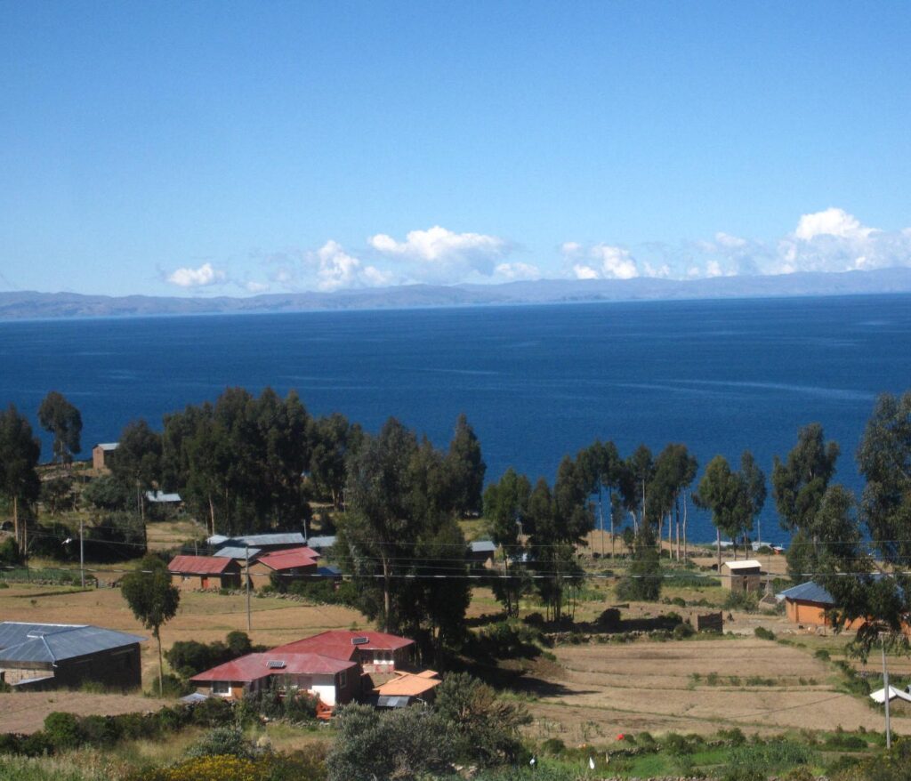
Tucked away on the Peruvian side of Lake Titicaca, Isla Amantaní is one of the least-visited islands in the region — and that’s precisely what makes it so special. Located just a few kilometers north of Isla Taquile, this tranquil island is home to about 4,000 residents and offers a rare opportunity to experience traditional Andean life in a setting untouched by cars, noise, or even dogs (which are not permitted on the island).
Though many travelers pass through the area on day trips without continuing to Amantaní, those who make the journey are rewarded with unforgettable views, cultural immersion, and a warm welcome through local homestays.
Almost all visitors to Amantaní participate in a community-run homestay, managed by the Amantaní Community Lodging association. Upon arrival, guests are assigned to families through a rotating system designed to ensure fair distribution of tourism income among households. If you’re traveling with others, you can request to stay together — just be sure to respect the rotation process, even when part of a guided tour.
Meals are home-cooked and typically include regional staples such as fresh fish, quinoa, and local vegetables. While there are a few small shops offering snacks, don’t expect restaurants or bars — the experience here is intentionally simple and authentic.
The islanders primarily speak Quechua, but their culture has strong Aymara influences. You may be invited to join a traditional music and dance night, where guests dress in local attire and dance alongside their hosts in the village gathering halls — an experience that’s both joyful and humbling (though your hiking boots might betray your outsider status).
At night, the lack of artificial light makes for some of the clearest stargazing in Peru. Take a moment to look up on your walk back to your host family’s home — the sky here is unforgettable.
Isla Amantaní is dotted with gentle hills, some of which are topped by ancient ruins from the Tiwanaku civilization — a pre-Incan culture that thrived around Lake Titicaca between 200 BC and AD 1000. The two most notable sites are:
Pachamama (Mother Earth)
Pachatata (Father Earth)
Both offer stunning panoramic views of the lake and surrounding mountains. If you’re there on January 20th, you may witness local ceremonies held at these sites, celebrating ancestral traditions.
Daily ferries depart Puno’s port at 8:30am (S/30 round trip; S/8 entrance fee).
Return boats to Puno usually leave Amantaní around 4pm, with occasional departures at 8am, depending on demand.
It’s also possible to travel between Amantaní and Isla Taquile, so you can explore both islands in one trip.
Private boat taxis between Llachón and Amantaní cost around S/100 return.
Ferry schedules can vary slightly, so confirm details in advance, especially if coordinating a return journey the same day.
Bring cash: There are no ATMs on the island.
Pack layers: Evenings can get cold at high altitude.
Walk slowly: The island sits at over 3800m, and altitude can affect your stamina.
Support your host: Purchase local crafts or leave a tip if you can — tourism is a vital part of the island economy.
Why Go?
Isla Amantaní offers more than just a scenic detour; it’s a peaceful window into highland Andean life, where hospitality runs deep and time seems to slow down. For travelers seeking meaningful cultural exchange in a natural setting, this remote island on Lake Titicaca is a quiet treasure.
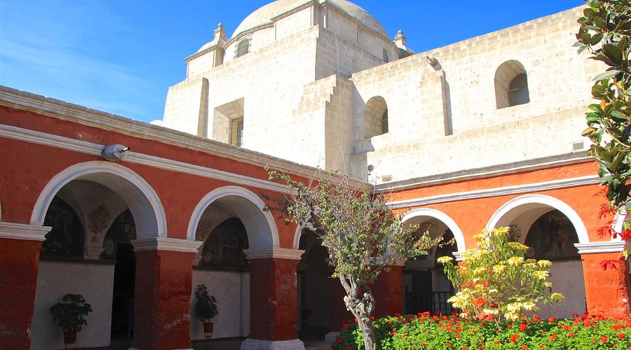
Even if you’ve seen your fair share of colonial architecture, Santa Catalina Monastery in Arequipa is not to be missed. Enclosed behind towering walls and occupying an entire city block, this 20,000-square-meter convent is more like a self-contained citadel than a single religious building. Founded in 1580 by the wealthy widow Doña María de Guzmán, it offers a unique window into the lives of cloistered nuns during Peru’s colonial era.
The best way to explore Santa Catalina is by hiring a local guide (available for S/20 at the entrance). Guides speak Spanish, English, French, German, Italian, Portuguese, and Japanese, and tours last about an hour. Afterward, you’re welcome to explore independently until closing time.
Twice a week, the monastery also opens its doors in the evening, allowing visitors to stroll through candlelit passageways just as the nuns once did — a truly atmospheric experience.
If you prefer to visit on your own, grab the miniature map printed on the back of your ticket and wander freely. The convent is a quiet, meditative place, and getting a little lost only adds to the experience.
Your visit begins under the “Silencio” arch, a symbolic entry into a world of quiet devotion. Here, novice nuns once lived under vows of silence, prayer, and hard work. Families of novices were required to pay a dowry of 100 gold coins per year during the four-year novice period. Only afterward could the women choose whether to take full vows or leave — though leaving often brought social shame.
Lined with orange trees that symbolize rebirth and eternal life, this cloister houses the Profundis Room, a small mortuary where nuns were mourned. The surrounding walls are lined with posthumous portraits of the deceased, hastily painted within 24 hours of death since painting living nuns was forbidden.
Walk along Córdova Street to see the former living cells. These rooms — varying from modest to extravagant — were homes for nuns and their servants. The range in luxury reflected the wealth of their families.
Toledo Street leads to the convent’s charming café, where you can enjoy fresh pastries and espresso. Nearby is the communal washing area, where servants once cleaned garments using diverted mountain runoff flowing into large earthenware jars.
Continue toward Burgos Street, where you can visit the original kitchen, which functioned as the main church until reforms in 1871. Beyond that lies Zocodober Square — named after an Arabic word meaning “barter” — where nuns would gather on Sundays to exchange handmade goods like soaps and baked treats.
Don’t miss the cell of Sor Ana, a legendary figure remembered for her prophetic visions and alleged miracles. Her room remains preserved as a site of quiet reflection.
End your visit at the Great Cloister, which is bordered by the chapel on one side and an art gallery on the other. The gallery, once a communal dormitory, is shaped like a cross and adorned with murals depicting scenes from the lives of Jesus and the Virgin Mary.
Allow at least 2–3 hours to fully explore.
Visit in the morning or late afternoon for fewer crowds.
Bring cash for entrance and guide fees.
Wear comfortable shoes — the stone walkways are uneven.
The monastery is centrally located, just a short walk from the Plaza de Armas in Arequipa.
Why Visit?
More than just a historic convent, Santa Catalina is a beautifully preserved time capsule of religious and social life in colonial Peru. With its colorful walls, peaceful courtyards, and layered history, it’s a highlight of any visit to Arequipa.
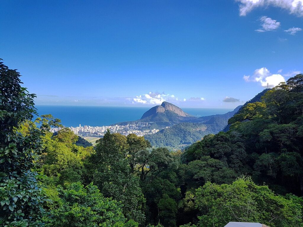
The Tijuca Forest is a 39 sq km tropical-jungle preserve and one of the last remaining pieces of the Atlantic rainforest that once blanketed Rio de Janeiro. Today, it’s a living, breathing green oasis in the city — home to towering trees, tumbling waterfalls, mysterious caves, and panoramic peaks. It’s a haven for nature lovers, families, and hikers alike.
At the heart of the forest lies Alto da Boa Vista, the main area of Floresta da Tijuca. It’s where you’ll find many of the park’s most scenic and historical attractions, including:
Cascatinha de Taunay, Cascata Gabriela, and Cascata Diamantina — picturesque waterfalls perfect for cooling off or snapping photos.
Capela Mayrink, a charming 19th-century pink chapel set among the trees.
Gruta Luís Fernandes, Gruta Belmiro, and Gruta Paulo e Virgínia — natural caves worth exploring.
Bom Retiro, a lovely picnic area surrounded by forest.
Restaurante Os Esquilos, a cozy and elegant option for lunch, and Restaurante Barão a Floresta, located near the ruins of Ruínas do Archer, the old home of Major Archer.
The park is famous for its excellent, well-marked trail system. Popular routes include the climb to Pico da Tijuca, the highest peak in the park at 1012m, offering sweeping views over Rio and beyond.
Along the way, you might encounter monkeys, iguanas, and dozens of bird species. You’ll also spot Candomblé offerings beside the paths — small tokens left by practitioners of this Afro-Brazilian religion.
Stop by the entrance for a free trail map, and make sure to head out early — the park closes at sunset.
By car is the easiest and most flexible way to reach the park. Here’s how:
From Jardim Botânico: Head east on Rua Jardim Botânico, pass the Botanical Garden, and turn left on Lopes Quintas. Follow the Tijuca or Corcovado signs through two quick turns. Once behind the garden, turn right and continue up through the forest past Vista Chinesa and Mesa do Imperador. Keep right, and after a couple of kilometers, you’ll see the stone columns marking the entrance to Alto da Boa Vista on your left.
From São Conrado: Head up the hill at the Parque Nacional da Tijuca signs.
From Barra da Tijuca: Drive north on Estrada da Barra da Tijuca, which turns into Rua da Boa Vista, offering several park access points.
Without a car? No problem. Guided hiking tours are available from companies like Jungle Me and Rio Adventures, providing transportation and local expertise.
Start early to beat the heat and explore before the park closes at sunset.
Bring water, snacks, sunscreen, and insect repellent.
Wear hiking shoes for traction on uneven trails.
Respect offerings along the trails and avoid touching them.
Check weather conditions before you go — trails can get slippery when wet.
Tijuca National Park is more than just a green space — it’s a vital piece of Rio’s natural and cultural heritage. Whether you’re after a peaceful picnic, a challenging hike, or a glimpse into Afro-Brazilian traditions, this rainforest in the city delivers.
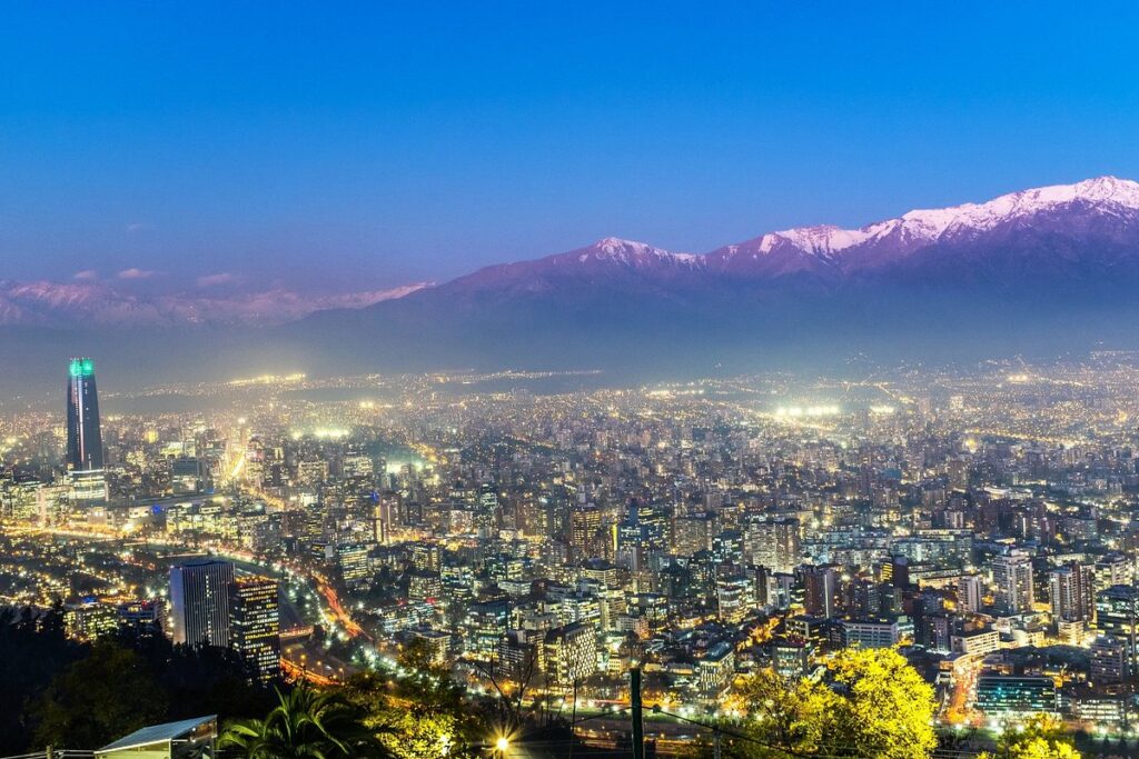
For sweeping panoramas of Santiago and the snow-dusted Andes beyond, head to Parque Metropolitano, better known as Cerro San Cristóbal. Spanning 722 hectares, it’s the largest green space in the city and one of its most beloved urban escapes.
Though vast, the park is very much part of the city’s fabric — accessible via both a funicular and a teleférico (cable car) that glide up and over its forested slopes, linking scenic spots and attractions.
At the summit, the park’s most iconic feature stands tall — a 14-meter white statue of the Virgen de la Inmaculada Concepción. This serene figure overlooks Santiago from a terrace where Pope John Paul II held Mass in 1984. Today, it remains a popular spot for reflection and for enjoying some of the best views in the city.
To reach the summit, you can:
Hike up a steep, winding dirt trail
Take the funicular from Plaza Caupolicán, which also hosts a tourist information kiosk
Ride the cable car from the Pedro de Valdivia entrance
There’s more to Cerro San Cristóbal than just views. The park is home to a range of attractions suited for all ages:
Zoológico Nacional – Chile’s national zoo, featuring native and exotic species
Jardín Botánico Mapulemu – A botanical garden focused on Chilean flora
Plaza de Juegos Infantiles Gabriela Mistral – A well-designed children’s play area with interactive fountains and wooden playgrounds
Piscina Tupahue and Piscina Antilén – Two large public swimming pools, ideal for summer visits
Jardín Japonés – A small but beautifully maintained Japanese garden, near the Pedro de Valdivia entrance
One of the best places to pause is the Terraza Bellavista, located near the top of the funicular. It offers a few snack stands and exceptional views over the city skyline and mountains beyond.
The park can be accessed from multiple points, most notably:
Bellavista neighborhood, via Plaza Caupolicán
Providencia neighborhood, via Pedro de Valdivia
The park is large; wear comfortable shoes if you plan to explore on foot.
Arrive early to avoid crowds, especially at the summit.
Check operating hours for the funicular, teleférico, and pools in advance, as they may vary seasonally.
Bring water and sun protection — the Chilean sun can be strong even in winter.
Cerro San Cristóbal blends nature, city views, and cultural landmarks in a single destination. Whether you’re looking for a peaceful escape or a memorable photo of Santiago, this is the place to be.
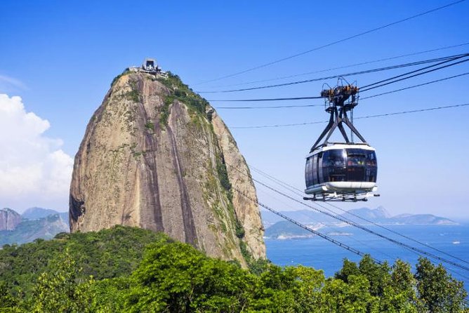
Seen from the summit of Pão de Açúcar, it’s easy to understand why Rio de Janeiro is known as the Cidade Maravilhosa (Marvelous City). The panoramic views from this granite peak are unforgettable, especially at sunset on a clear day, when the golden light spills over the bay, beaches, and surrounding mountains.
Pão de Açúcar rises 395 meters above the city and is accessible via two cable cars, which run every 20 minutes.
First Stage: Morro da Urca
The initial cable car climbs 215 meters to Morro da Urca, offering views over Guanabara Bay and the dramatic coastline. You’ll also spot Praia Vermelha on the ocean side of the mountain.
Morro da Urca features:
Souvenir shops
Snack bars
A concert venue (Arena Morro da Urca)
A helipad offering helicopter tours (via Helisight)
Second Stage: Pão de Açúcar Summit
The second cable car ascends to the peak itself. From here, you can see:
Corcovado and Christ the Redeemer to the west
Copacabana Beach stretching south
Endless city and ocean views in every direction
At the top, you’ll find the Clássico Beach Club, an open-sided bar serving tropical cocktails and upscale snacks — perfect if you need to steady your nerves after the ascent.
Go early in the morning to avoid crowds.
Avoid cloudy days — the experience is all about the views.
Sunset is stunning but draws the biggest crowds, so plan accordingly.
If you’d rather earn your view, there are alternatives to the cable car:
Morro da Urca Hike:
A short but steep 30-minute trail climbs through lush forest to Morro da Urca. The trail starts from the Pista Cláudio Coutinho, a scenic path at the base of the mountain. Though unmarked, it’s a popular route and often busy.
Rock Climbing:
For the adventurous, several local tour companies offer climbing routes up the granite face of Pão de Açúcar itself. These are best tackled with experienced guides.
Pão de Açúcar isn’t just one of the best views in Rio — it’s one of the best in the world. Whether you hike, climb, or take the cable car, the summit delivers an unforgettable experience.
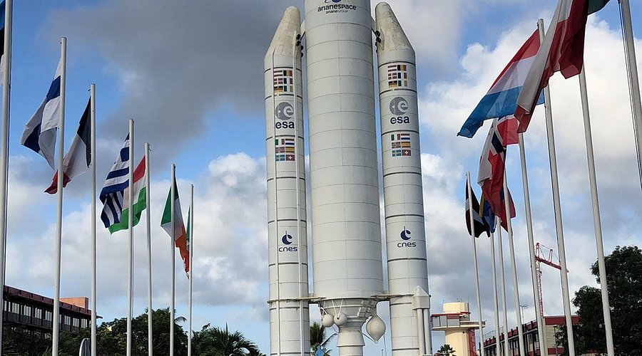
Visiting the Centre Spatial Guyanais (CSG) in Kourou — and, if you’re lucky, witnessing a rocket launch — is one of French Guiana’s most extraordinary experiences. But it requires advance planning, so be sure to prepare early.
To take a tour of the space center, you must register at least 48 hours in advance. You can apply online or by phone, providing your passport details. Tours are free but tightly regulated due to the site’s active launch schedule and security protocols.
The standard three-hour bus tour includes a visit to the launchpad and mission control facilities. It’s a rare opportunity to explore one of the world’s leading spaceports up close.
Seeing a live launch at CSG is a truly unforgettable experience. With over a dozen launches per year, your odds of witnessing one are decent — if your visit is well-timed.
To reserve a spot at one of the official observation points within the center, email:
csg-accueil@cnes.fr
Include:
Full name
Age
Address
Phone number
Important:
Children under 16 are not permitted within 6km of the launch site.
Children under 8 are not permitted within 12km.
Entry is free, but space is limited, so reserve early.
If you can’t get a reservation, locals often gather at Kourou’s beaches or at the Carapa Observation Site (15km west of the city center) to watch launches without a formal booking.
The CSG was established in 1964 for its optimal location:
Near the equator, which gives rockets a natural speed boost due to Earth’s rotation (the “slingshot effect”)
Free from earthquakes and hurricanes
Low population density for safety
Its location makes launches up to 17% more energy-efficient, and since 1980, over two-thirds of the world’s commercial satellites have lifted off from here.
The facility is jointly operated by:
CNES (French Space Agency)
ESA (European Space Agency)
Arianespace
Bring your passport – it’s required for both the tour and attending launches.
Tours are closed the day before, the day of, and the day after a launch.
If a launch is postponed, the closure period extends.
That makes it difficult to combine a tour and a launch in a short visit, so plan for flexibility.
Some guides speak English or German – ask when booking.
Tip: Visit ESA’s website or Arianespace for updated launch schedules.
Whether you’re here for a tour or a launch, a visit to the Centre Spatial Guyanais offers a rare glimpse into the cutting edge of space exploration — in one of the most unexpected places on Earth.
Amun-Ra, originally the local god of Karnak (Luxor), rose to become the chief state deity during Egypt’s New Kingdom, when the princes of Thebes ruled. His temple grew to immense wealth and power, owning hundreds of thousands of cattle, cities, ships, vast agricultural lands, and employing tens of thousands.
Though the temple was sacked by Assyrians and Persians, the surviving ruins remain among the world’s most impressive archaeological sites.
The Quay of Amun
This was the docking area where boats carrying statues of the gods moored during festivals. Nearby stood palaces and lush gardens. A ramp leads to the processional avenue lined with ram-headed sphinxes, guiding visitors to the massive unfinished first pylon, built during Nectanebo I’s reign. The pylon still shows the enormous mud-brick ramp used to haul stone blocks.
Great Court
Beyond the first pylon lies the largest courtyard in the complex. It contains:
The Shrine of Seti II with three chapels housing sacred barques of Mut, Amun, and Khonsu.
The Temple of Ramses III, a smaller copy of his Medinat Habu temple, with a central papyrus-column and an alabaster altar — remnants of Taharka’s kiosk.
The second pylon was begun by Horemheb and continued by Ramses I and II, who placed colossal granite statues of himself here.
Great Hypostyle Hall
A monumental hall covering 5,500 sq m, filled with 134 towering papyrus-shaped stone columns symbolizing the primeval swamp from which life emerged. The hall was built by Seti I and Ramses II — note the more refined reliefs by Seti I and the cruder ones by Ramses II. The hall once flooded during Nile inundations and was originally brightly painted.
Third and Fourth Pylons and Inner Temple
The third pylon, built by Amenhotep III, features scenes of the pharaoh sailing the sacred barque during the Opet Festival.
Between the third and fourth pylons is a narrow court where four obelisks stood; only one remains standing, erected by Tuthmosis I.
The fourth pylon leads to a hypostyle hall built by Tuthmosis I and III, with the tallest surviving Egyptian obelisk — erected by Queen Hatshepsut, originally capped with electrum.
Nearby stand statues of Amun and Amunet carved during Tutankhamun’s reign.
Sanctuary of Amun
The temple’s innermost sanctuary, originally built by Tuthmosis III, was destroyed during Persian invasions and later rebuilt in granite by Philip Arrhidaeus.
Middle Kingdom Court and Wall of Records
The oldest temple area, containing foundations of Sesostris I’s shrine and a wall recording tributes to Amun from subjugated lands.
Great Festival Hall of Tuthmosis III
A tent-like stone hall decorated with reliefs of plants and animals brought back from campaigns in Syria and Palestine.
Cachette Court (between Hypostyle Hall and seventh pylon): where thousands of statues were buried by priests around 300 BC to protect them.
Eighth Pylon: oldest north–south pylon built by Hatshepsut, inscribed with a text justifying her rule.
Sacred Lake: used for ritual bathing by priests of Amun, located east of the pylons.
Temple of Khonsu: dedicated to the moon god, son of Amun and Mut, built mostly by Ramses III and expanded by Ramesside rulers; accessible through the Hypostyle Hall.
Take your time in the Hypostyle Hall to appreciate its vastness and artistry.
Look for contrasts in relief styles reflecting different pharaohs’ periods.
Notice the symbolic elements such as papyrus columns and sphinx avenues.
WhatsApp us